India is a vast country located in the Northern Hemisphere, forming a major part of the Indian subcontinent.
Its mainland spans approximately 30 degrees of latitude and longitude, leading to diverse climatic conditions.
Geologically, India is a mosaic of three primary units: the ancient Peninsular Block, the young Himalayan mountains, and the alluvial Indo-Gangetic plain.
Geographical Extent and Frontiers
Location: Entirely in the Northern Hemisphere, specifically in the south-central part of Asia.
Latitudinal Extent:8°4'N to 37°6'N. This vast spread means the southern part is in the tropics and the northern part in the sub-tropics.
Longitudinal Extent:68°7'E to 97°25'E. This creates a time lag of nearly 2 hours between the east and west.
Dimensions:
North-South Extent: 3,214 km (from Indira Col in Ladakh to Kanyakumari).
East-West Extent: 2,933 km (from the Rann of Kutch to Arunachal Pradesh).
Southernmost Point: The southernmost point of the Indian mainland is Kanyakumari. However, the southernmost point of the Indian Union is Indira Point in the Andaman and Nicobar Islands, which was submerged during the 2004 Tsunami.
Tropic of Cancer: Passes through the middle of India at 23°30'N, dividing it into almost equal tropical and sub-tropical zones. It passes through 8 Indian states: Gujarat, Rajasthan, Madhya Pradesh, Chhattisgarh, Jharkhand, West Bengal, Tripura, and Mizoram.
Indian Standard Time (IST): To standardize time, the meridian of 82°30'E is taken as the Standard Meridian of India. It passes through Mirzapur in Uttar Pradesh and is 5 hours 30 minutes ahead of Greenwich Mean Time (GMT).
Additional Exam-Oriented Points:
India's total area is 3.28 million sq. km, which is 2.4% of the total geographical area of the world.
India is the 7th largest country in the world by area.
Total land frontier: ~15,200 km.
Total coastline (including islands): ~7,516.6 km.
India shares its land border with 7 countries: Bangladesh (longest border), China, Pakistan, Nepal, Myanmar, Bhutan, and Afghanistan (shortest border).
The Palk Strait and Gulf of Mannar separate India from Sri Lanka.
The eight-degree channel separates Lakshadweep from the Maldives.
The state with the longest coastline is Gujarat.
Uttar Pradesh shares its border with the maximum number of states (8 states and 1 UT).
India's strategic location at the head of the Indian Ocean is significant for international trade routes.
Characterized by relict and residual mountains like the Aravallis and block mountains/rift valleys like the Satpuras and Narmada valley.
This block contains some of the oldest rock systems, including the Dharwar System, known for valuable mineral resources.
The Himalayas and Peninsular Mountains:
Geologically young, weak, and flexible folded mountains.
Formed by the tectonic collision of the Indian and Eurasian plates, an ongoing process. This convergence resulted in the uplift of sediments from the Tethys Sea.
Highly susceptible to earthquakes and landslides due to their tectonic instability. They are still rising in height.
Indo-Ganga-Brahmaputra Plain:
A vast geosynclinal depression between the Himalayas and the Peninsula.
Filled with thick alluvial deposits (1,000-2,000m) from Himalayan and Peninsular rivers.
One of the most extensive and fertile alluvial plains globally, formed during the Pleistocene and Holocene epochs.
Archaean Rock System: Oldest rocks, form the foundation of the Peninsular plateau. They are gneisses and schists, devoid of fossils. Known as the 'Basement Complex'.
Dharwar System: Oldest sedimentary rocks, formed by the erosion of Archaean rocks. Economically most important for metallic minerals like iron ore, manganese, gold, and copper.
Cuddapah System: Formed from the erosion of Dharwar rocks. Rich in non-metallic minerals like limestone, sandstone, and asbestos.
Vindhyan System: Known for building materials like sandstone (used in Sanchi Stupa, Red Fort) and limestone (cement industry). Also famous for diamond mines (Panna).
Gondwana System: Formed during the Carboniferous period. Contains nearly 98% of India's coal reserves. Major coalfields like Damodar, Godavari, and Mahanadi valleys belong to this system.
Deccan Traps: Formed by massive volcanic eruptions at the end of the Cretaceous period. Composed of basaltic lava, which has weathered into black soil (regur), ideal for cotton.
Tertiary System: Corresponds to the formation of the Himalayas. Important for petroleum and natural gas deposits found in Assam, Gujarat, and Mumbai High.
Quaternary System: Represents the recent geological period. Includes the formation of the Indo-Gangetic plains (alluvium) and the Karewas of Kashmir (lacustrine deposits).
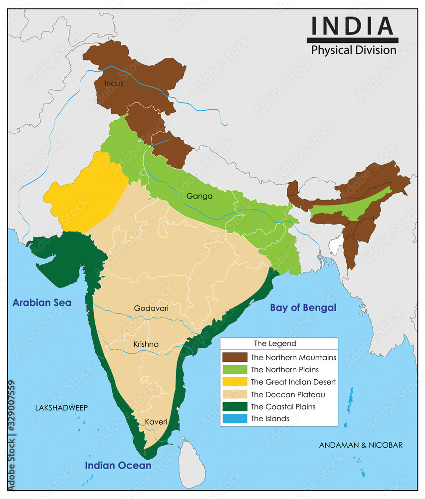
2. Physiographic Divisions of India
India's diverse geology has resulted in a landscape of immense contrasts. It is broadly divided into six distinct physiographic units:
Source: Wikimedia Commons, based on Survey of India data
The Northern and Northeastern Mountains: A series of young fold mountain ranges acting as a climatic and physical barrier. Learn more.
The Northern Plain: A vast, fertile alluvial plain formed by the depositional work of major river systems. Learn more.
The Peninsular Plateau: An ancient and stable tableland composed of old crystalline rocks. Learn more.
The Indian Desert: A hot, arid sandy plain located to the northwest of the Aravalli Hills. Learn more.
The Coastal Plains: Narrow strips of flat land flanking the Peninsular Plateau on the east and west. Learn more.
The Islands: Two major island groups, one in the Arabian Sea and the other in the Bay of Bengal. Learn more.
Significance of Each Division:
The Northern Mountains: Act as a climatic divide, preventing cold Siberian winds from entering India and forcing monsoon winds to rain. They are a source of perennial rivers, rich in forest wealth and biodiversity, and act as a natural defense barrier.
The Northern Plains: Considered the 'granary of India', these fertile plains support a large population and intensive agriculture. They are the cradle of major ancient civilizations and are crucial for the country's economy and food security.
The Peninsular Plateau: A storehouse of mineral resources like coal, iron, manganese, and bauxite. The black soil of the Deccan Trap is vital for cotton cultivation. The plateau's rivers have high potential for hydroelectric power.
The Indian Desert: Despite its aridity, it is a source of minerals like gypsum and salt. It has high potential for solar and wind energy generation. The Indira Gandhi Canal has transformed parts of the desert, enabling agriculture.
The Coastal Plains: Support agriculture (especially rice), fishing, and aquaculture. The plains host major ports that are gateways for international trade. The backwaters (kayals) are important for tourism and navigation.
The Islands: They are of immense strategic importance. The Andaman and Nicobar Islands are home to unique tribal groups and are rich in biodiversity with equatorial forests. The Lakshadweep islands are famous for their pristine coral reefs.
3. The Himalayas
The Himalayas, or 'abode of snow', are a series of parallel mountain ranges forming India's northern boundary. They are a climatic, drainage, and cultural divide.
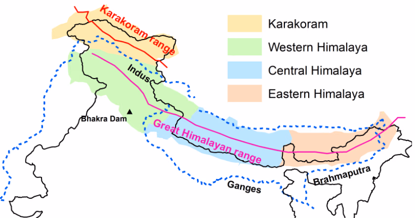
Longitudinal Divisions
The Great Himalayas (Himadri):
Northernmost and highest range; average elevation 6,000m.
Source of major perennial rivers like Ganga and Yamuna (Gangotri and Yamunotri glaciers).
The folds are asymmetrical with a steep south slope and a gentle north slope.
The Lesser Himalayas (Himachal):
South of Himadri; average altitude 3,700-4,500m.
Composed of highly compressed rocks.
Important ranges: Pir Panjal, Dhaula Dhar, Mahabharat.
Known for famous valleys like Kashmir, Kangra, and Kullu, and hill stations: Shimla, Mussoorie, Nainital.
Characterized by 'Shiwalik-type' formations and dense forests of coniferous and broad-leaved trees.
The Shiwaliks (Outer Himalayas):
Outermost range; average altitude 900-1,100m.
Composed of unconsolidated sediments brought by rivers from the main Himalayan ranges.
Longitudinal valleys between Himachal and Shiwaliks are called 'Duns' (e.g., Dehradun, Kotli Dun, Patli Dun).
These ranges are prone to landslides and earthquakes.
The eastern part of the Shiwalik range is called 'Duars'.
The Trans-Himalayas:
North of Himadri; includes Karakoram, Ladakh, Zaskar ranges.
Location of K2 (Godwin Austen), the second-highest peak in the world.
Contains major glaciers like Siachen.
It is a cold desert region lying in the rain-shadow of the Himalayas.
The Indus river flows between the Ladakh and Zaskar ranges.
Regional Divisions (West to East)
Regional classification of the Himalayas based on river valleys. Source: Wikimedia Commons
Punjab Himalayas: Between Indus and Satluj rivers. (Also known as Kashmir/Himachal Himalaya). Features include the Kashmir Valley and Karewa formations, which are lacustrine deposits famous for saffron cultivation. Learn about Karewas.
Kumaon Himalayas: Between Satluj and Kali rivers. Features Nanda Devi peak. The famous 'Valley of Flowers' is located here.
Nepal Himalayas: Between Kali and Tista rivers. Contains the highest peaks like Everest, Kanchenjunga, and Makalu.
Assam Himalayas: Between Tista and Dihang rivers. These ranges are lower in elevation compared to the Nepal Himalayas.
The Eastern Hills (Purvanchal)
Beyond the Dihang gorge, the Himalayas bend south along India's northeastern boundary.
Composed of strong sandstones and covered with dense forests.
Includes ranges like the Patkai hills, Naga hills, Manipur hills, and Mizo hills (also known as the Lushai Hills). These hills are arranged in parallel ranges and valleys.
The Barak is an important river in Manipur and Mizoram.
Loktak lake in Manipur is famous for its floating islands (Phumdis).
Additional Exam-Oriented Points:
A 'syntaxial bend' is a sharp, hairpin bend in the mountain ranges, found at Namcha Barwa in the east and Nanga Parbat in the west.
Important Passes: Zoji La (Srinagar-Leh), Banihal (Jammu-Srinagar), Shipki La (Himachal-Tibet), Nathu La (Sikkim-Tibet), Bom Di La (Arunachal-Tibet).
'Bugyals' are high-altitude alpine grasslands in Uttarakhand.
The formation of Himalayas is explained by the theory of Plate Tectonics.
The Siachen Glacier is the highest battlefield in the world.
The Himalayas are a major biodiversity hotspot, with distinct altitudinal vegetation zones.
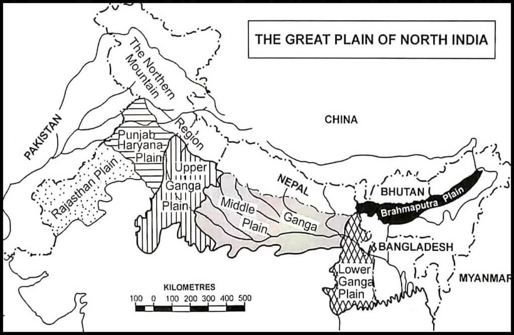
4. The Northern Plains
Formed by the alluvial deposits of the Indus, Ganga, and Brahmaputra river systems, the Northern Plains are one of the most fertile and densely populated regions on Earth.
Physiographic Divisions of the Plains
Relief features of the Northern Plains from north to south. Source: ResearchGate
Bhabar:
A narrow, 8-16 km belt of pebbles and boulders parallel to the Shiwaliks.
Highly porous; streams disappear here.
Not suitable for agriculture due to its coarse nature.
Characterized by deposition of coarse materials like boulders and pebbles.
Terai:
South of Bhabar; a 10-20 km wide swampy and marshy region.
Underground streams re-emerge here.
Rich in forests and wildlife. Large parts have been cleared for agriculture (e.g., sugarcane, rice).
Historically, it was a thickly forested region with a high incidence of malaria.
Bhangar:
Largest part of the plains, formed of older alluvium.
Forms a terrace-like feature above the floodplains.
Contains calcareous concretions called Kankar. This soil is less fertile than Khadar.
Found further away from the river courses.
Khadar:
Newer, younger alluvium of the floodplains.
Renewed annually by floods, making it extremely fertile.
Ideal for intensive cultivation of crops like rice, wheat, and maize.
Characterized by fine silt and clay.
Regional Divisions of the Plains
Punjab Plains: The western part, formed by the Indus and its tributaries. A large portion lies in Pakistan. Characterized by numerous 'doabs' (land between two rivers).
Ganga Plains: Extends between the Ghaggar and Tista rivers. It is further divided into Upper, Middle, and Lower Ganga Plains.
Brahmaputra Plains: The easternmost part of the plains, primarily in Assam. Known for its riverine islands and frequent floods.
Additional Exam-Oriented Points:
The plains are a monotonously flat region with an imperceptible slope.
'Doab' literally means 'two waters'. Important doabs include Sindh Sagar, Jech, Rechna, Bari, and Bist Doabs in Punjab.
The 'Rohilkhand Plains' are part of the Upper Ganga Plain.
The 'Magadh' and 'Mithila' plains are part of the Middle Ganga Plain.
Majuli in the Brahmaputra is the world's largest inhabited riverine island.
The plains are crucial for the Green Revolution's success in India.
The Delhi Ridge is an extension of the Aravalli hills and marks the western boundary of the Ganga plains.
The plains are characterized by mature stage features of rivers, such as meanders, ox-bow lakes, and braided channels.
5. The Peninsular Plateau
This is a tableland composed of ancient crystalline, igneous, and metamorphic rocks. It is one of the oldest and most stable landmasses of India. The Narmada river divides it into two broad parts.
The Central Highlands
Lies north of the Narmada river, covering the Malwa Plateau.
Bounded by the Aravalli Range in the northwest. The Aravallis are one of the world's oldest fold mountain systems, now heavily eroded into residual hills. More on Aravallis.
Slope is from southwest to northeast, as indicated by the flow of rivers like Chambal and Betwa.
Eastward extensions are known as Bundelkhand and Baghelkhand.
The Chotanagpur Plateau marks its further eastern extent and is a storehouse of minerals like coal, iron ore, and manganese.
The Deccan Plateau
A triangular landmass south of the Narmada river.
Bounded by the Satpura range, Mahadeo hills, and Maikal range in the north.
Western Ghats (Sahyadris):
Form the western edge; they are continuous and higher than the Eastern Ghats.
Important peaks: Anaimudi (2,695 m) in the Anaimalai Hills and Doda Betta (2,637 m) in the Nilgiri Hills.
Important passes include Thal Ghat, Bhor Ghat, and Pal Ghat which provide routes to the coastal plains.
Eastern Ghats:
Form the eastern edge; they are discontinuous and lower.
Dissected by major rivers like Godavari and Krishna.
Highest peak: Mahendragiri (1,501 m). Other prominent hills include Javadi Hills and Shevaroy Hills.
The Deccan Trap is a distinct feature of black soil (Regur) of volcanic origin, ideal for cotton. It was formed by voluminous fissure eruptions during the Cretaceous period. Learn about the Deccan Traps.
Additional Exam-Oriented Points:
The highest peak of the Aravallis is Guru Shikhar on Mount Abu.
The Malwa plateau has been extensively eroded by the Chambal river and its tributaries, forming 'badland topography' or 'ravines'.
The Chotanagpur plateau is known as the 'Ruhr of India' due to its rich mineral deposits.
The Meghalaya (or Shillong) Plateau is an extension of the Peninsular block, separated by the Malda Gap. It includes the Garo, Khasi, and Jaintia hills.
The Satpura range is a block mountain with the Narmada rift valley to its north and the Tapi rift valley to its south. Its highest peak is Dhupgarh.
The Nilgiri Hills are a meeting point of the Western and Eastern Ghats.
The Cardamom Hills are the southernmost hills of India.
The Deccan plateau is tilted towards the east, which is why major peninsular rivers flow into the Bay of Bengal.
6. The Indian Desert
Located northwest of the Aravalli hills, it is also known as the Thar Desert.
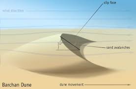
An undulating sandy plain with various types of sand dunes.
Receives very low rainfall (<150 mm per year), resulting in an arid climate (Marusthali).
Features crescent-shaped dunes (barchans) and longitudinal dunes. Barchans are more prominent in the western part.
The Luni is the only significant ephemeral river in this region, which disappears into the marshy Rann of Kutch.
Features several saline lakes or playas, such as Sambhar Lake, from which salt is extracted.
Barchan (crescent-shaped) sand dunes in the Thar Desert. Source: Wikimedia Commons
Additional Exam-Oriented Points:
The desert is believed to be a result of the rain-shadow effect of the Aravallis and Pleistocene climatic changes.
It can be divided into two parts: the arid region called Marusthali and the semi-arid region to its east called Bagar.
Longitudinal dunes are more common in the southern part of the desert.
Oases are fertile spots in the desert where groundwater is available.
The Indira Gandhi Canal has brought water to large parts of the desert, transforming agriculture.
The region has a high diurnal range of temperature.
It supports a unique ecosystem with adapted flora (like Khejri trees) and fauna (like the Great Indian Bustard).
The desert region has significant reserves of gypsum, limestone, and lignite.
7. The Coastal Plains
The Western Coastal Plains:
A narrow plain between the Western Ghats and the Arabian Sea.
It is a submerged coastal plain, excellent for natural harbours like Mumbai and Kandla.
The rivers here are short, swift and form estuaries rather than deltas.
The Malabar Coast is famous for its backwaters (Kayals), which are used for fishing, inland navigation, and tourism.
The Eastern Coastal Plains:
A wider plain between the Eastern Ghats and the Bay of Bengal.
It is an emergent coast, with a smooth shoreline and fewer natural ports. Chennai and Visakhapatnam are major ports.
Divided into: Northern Circar (north) and the Coromandel Coast (south).
Features large, well-formed deltas of the Mahanadi, Godavari, Krishna, and Kaveri rivers, making it very fertile.
Chilika Lake in Odisha, India's largest saltwater lake, and Pulicat Lake on the Andhra-Tamil Nadu border are prominent features.
Additional Exam-Oriented Points:
The Kutch peninsula was once an island surrounded by seas and lagoons.
The Konkan coast is known for its cliffed shores and rocky terrain.
The Nehru Trophy Boat Race is held in the Punnamada Kayal in Kerala.
The Eastern Coastal Plain is wider because the east-flowing rivers have a larger depositional area.
The Coromandel Coast receives rainfall during winter from the retreating northeast monsoons.
The Godavari-Krishna delta region is known as the 'Rice Bowl of South India'.
Sand dunes are a common feature along the Odisha coast (also called Utkal coast).
Kolleru Lake is a large freshwater lake located between the Godavari and Krishna deltas.
8. The Islands
Lakshadweep Islands:
Located in the Arabian Sea.
A group of 36 islands of coral origin. Many are atolls, which are ring-shaped coral reefs.
Kavaratti is the administrative capital.
Rich in coral reefs and marine biodiversity.
Pitti Island, which is uninhabited, has a bird sanctuary.
Andaman & Nicobar Islands:
Located in the Bay of Bengal.
A chain of around 572 islands, believed to be an elevated portion of a submarine mountain range (the Arakan Yoma).
Separated by the 10-degree channel into the Andamans (north) and Nicobars (south).
Features India's only active volcano on Barren Island.
Hosts a diverse equatorial vegetation. The highest peak in the Andamans is Saddle Peak, and in the Nicobars is Mount Thullier.
These islands are of great strategic importance to India.
Additional Exam-Oriented Points:
The Laccadive, Minicoy, and Amindivi Islands were renamed Lakshadweep in 1973.
Minicoy is the largest island in the Lakshadweep group.
The 9-degree channel separates Minicoy from the rest of Lakshadweep.
The Andamans are further divided into Great Andamans (North, Middle, South) and Little Andaman.
The Duncan Passage separates South Andaman from Little Andaman.
Port Blair, the capital, is located in South Andaman. The infamous Cellular Jail is also here.
Narcondam Island is a dormant volcano in the Andaman Sea.
Indigenous tribes like the Jarawa, Onge, Sentinelese, and Shompen inhabit these islands.
The southernmost point, Indira Point, is in the Great Nicobar island.
9. Drainage Systems of India
Key Takeaways
India's drainage systems are broadly classified into two major groups: the **Himalayan System** and the **Peninsular System**.
Himalayan rivers are **perennial**, fed by glaciers and rain, and are in a youthful stage, forming deep gorges.
Peninsular rivers are mostly **seasonal** (non-perennial), dependent on monsoon rainfall, and are in a mature stage.
Drainage patterns like **dendritic, radial, and trellis** are outcomes of the region's topography and geological structure.
East-flowing Peninsular rivers form **deltas**, while west-flowing ones form **estuaries**.
Understanding Drainage Patterns
A drainage pattern is the spatial arrangement of rivers and their tributaries in a region. It is heavily influenced by the nature of the underlying rock structure, topography, and slope.
Dendritic Pattern:
Resembles the branching of a tree.
Develops where the river channel follows the slope of the terrain.
The underlying rock structure is uniform and does not control the flow of the river.
Rivers originate from a central hill or peak and flow in all directions.
Develops on well-developed domes or volcanic cones.
Example: The rivers originating from the Amarkantak Plateau (Narmada, Son).
Trellis Pattern:
Develops in regions of folded topography where hard and soft rocks exist parallel to each other.
Primary tributaries flow parallel to each other in valleys, and secondary tributaries join them at near right angles.
Example: Found in the folded mountains of the Himalayas.
Centripetal Pattern:
Rivers discharge their waters from all directions into a central lake or depression.
This is the opposite of a radial pattern.
Example: Loktak Lake in Manipur.
The Himalayan River Systems
Characteristics: These rivers are perennial as they are fed by both glaciers and rain. They have long courses from their source to the sea and perform intensive erosional activity, forming deep gorges, V-shaped valleys, rapids, and waterfalls. Many are antecedent rivers, meaning they existed before the Himalayas were uplifted and cut their way through the rising mountains.
The Indus River System
Source: Near Lake Manasarovar in Tibet from the Chemayungdung glacier. Known as 'Singi Khamban' (Lion's mouth) in Tibet.
Course: Flows northwest through Ladakh and Baltistan; cuts a deep gorge near Gilgit. Enters Pakistan near Chilas.
Indus Water Treaty: As per the 1960 treaty, India can use 20% of the total water carried by the Indus river system.
Major Tributaries (The Panjnad):
Jhelum: Rises from a spring at Verinag (Pir Panjal range). Flows through Srinagar and Wular Lake. Joins the Chenab in Pakistan. (Ancient name: Vitasta).
Chenab: Largest tributary of the Indus. Formed by two streams, the Chandra and the Bhaga, which meet at Tandi in Himachal Pradesh. (Ancient name: Asikni).
Ravi: Rises west of the Rohtang Pass in the Kullu hills of Himachal Pradesh. (Ancient name: Parushni).
Beas: Rises from the Beas Kund near Rohtang Pass. Meets the Satluj near Harike in Punjab. It is the only tributary that flows entirely within India. (Ancient name: Vipasha).
Satluj: Originates from the Rakas lake near Manasarovar in Tibet. It is an antecedent river and enters India through the Shipki La pass. The Bhakra Nangal project is on this river. (Ancient name: Shutudri).
The Ganga River System
Source: Rises in the Gangotri glacier near Gaumukh in Uttarakhand as the Bhagirathi.
Formation: At Devprayag, the Bhagirathi meets the Alaknanda; hereafter, it is known as the Ganga. The Alaknanda system itself is formed by five confluences (Panch Prayag).
Right-Bank Tributaries:
Yamuna: Longest tributary. Rises from the Yamunotri glacier. Joins the Ganga at Prayagraj. Its own tributaries include the Chambal, Betwa, and Ken.
Son: A large south-bank tributary originating from the Amarkantak Plateau.
Damodar: Known as the 'Sorrow of Bengal', it joins the Hooghly (a distributary of Ganga). Rich in mineral resources, its valley is called the 'Ruhr of India'.
Left-Bank Tributaries:
Ramganga: Rises in the Garhwal hills. Joins the Ganga near Kannauj.
Ghaghara: Rises in the glaciers of Mapchachungo. Joins the Ganga at Chhapra.
Gandak: Rises in the Nepal Himalayas. Joins the Ganga at Sonpur near Patna.
Kosi: An antecedent river, known as the 'Sorrow of Bihar' due to frequent flooding and course shifting.
Delta: The Ganga, along with the Brahmaputra, forms the world's largest delta, the Sunderbans Delta.
The Brahmaputra River System
Source: Originates in the Chemayungdung glacier of the Kailash range, near Manasarovar Lake in Tibet.
Names: Known as Tsangpo ('the purifier') in Tibet. Enters India in Arunachal Pradesh as the Dihang. In Bangladesh, it is known as the Jamuna.
Course: Flows eastward parallel to the Himalayas in Tibet. Takes a U-turn around Namcha Barwa and enters India.
Characteristics: A river of great volume, known for flooding, channel shifting, and creating braided channels. Forms the Majuli island, the world's largest riverine island.
Major Tributaries: Dibang, Lohit, Subansiri, Manas, Tista.
The Peninsular River Systems
Characteristics: These rivers are much older than the Himalayan rivers. They are mostly seasonal (non-perennial), as their flow depends on monsoon rainfall. They have shorter and shallower courses and are in a mature stage, characterized by broad valleys.
East-Flowing Rivers (form Deltas)
Mahanadi: Rises in the highlands of Chhattisgarh. Flows through Odisha to drain into the Bay of Bengal. The Hirakud Dam is on this river.
Godavari: The largest Peninsular river, also known as the 'Dakshin Ganga' or 'Vridha Ganga'. Rises from the slopes of the Western Ghats in the Nasik district of Maharashtra.
Krishna: Rises from a spring near Mahabaleshwar. The Tungabhadra and the Bhima are its major tributaries. Nagarjuna Sagar dam is a major project on this river.
Kaveri: Rises in the Brahmagiri range of the Western Ghats. It carries water throughout the year as its upper catchment receives rain from the southwest monsoon and the lower catchment from the northeast monsoon. This makes it a perennial peninsular river.
West-Flowing Rivers (form Estuaries)
Narmada: Rises in the Amarkantak hills. Flows westwards through a rift valley between the Vindhya and Satpura ranges. Known for the Dhuandhar falls near Jabalpur and Sardar Sarovar Dam.
Tapi (or Tapti): Rises in the Satpura ranges. Also flows through a rift valley parallel to the Narmada but is much shorter.
Other Rivers: Sabarmati, Mahi, Periyar are other significant west-flowing rivers. The Mahi river is unique as it crosses the Tropic of Cancer twice.
Comparison: Himalayan vs. Peninsular Rivers
Feature
Himalayan Rivers
Peninsular Rivers
Origin
Originate from snow-covered Himalayan mountains (Glaciers).
Originate in the Peninsular Plateau and Central Highlands.
Nature of Flow
Perennial; receive water from glaciers and rainfall.
Seasonal; dependent on monsoon rainfall. (Exception: Kaveri)
Nature of River
Long course, youthful stage, high erosive power, course shifting.
Shorter, fixed course with well-adjusted valleys, mature stage.
Catchment Area
Very large basins.
Relatively smaller basins.
Landforms
Form deep gorges, V-shaped valleys, and large deltas.
Flow in broad, shallow valleys and form estuaries (west-flowing) or smaller deltas (east-flowing).
Additional Exam-Oriented Points:
The 'Panch Prayag' in order are: Vishnuprayag (Alaknanda + Dhauliganga), Nandaprayag (Alaknanda + Nandakini), Karnaprayag (Alaknanda + Pindar), Rudraprayag (Alaknanda + Mandakini), and Devprayag (Alaknanda + Bhagirathi).
The Hooghly is a distributary of the Ganga in West Bengal.
The Chambal river is famous for its badland topography.
The Luni river is an inland drainage river that does not reach the sea.
Jog Falls (or Gerusoppa falls) on the Sharavathi river in Karnataka is one of the highest waterfalls in India.
The Kaveri water dispute is primarily between Karnataka and Tamil Nadu.
The National Waterway 1 is on the Ganga river, and National Waterway 2 is on the Brahmaputra.
10. Climate of India
India's climate is broadly described as the monsoon type. However, this broad unity coexists with significant regional variations.
Factors Affecting India's Climate
Latitude: The Tropic of Cancer divides the country, giving it both tropical and sub-tropical characteristics.
The Himalayas: Act as a massive barrier, protecting India from cold northern winds and trapping monsoon winds, forcing them to shed rain.
Distribution of Land and Water: The differential heating of the vast landmass and the surrounding Indian Ocean creates the monsoon pressure systems.
Altitude & Relief: Temperature decreases with height (e.g., Darjeeling is cooler than Agra on the same latitude). The Western Ghats cause orographic rain.
Distance from the Sea: Coastal areas experience a moderate or equable climate, while interior areas have an extreme or continental climate with a high diurnal range of temperature.
Jet Streams: The Sub-Tropical Westerly Jet Stream in winter and the Tropical Easterly Jet Stream in summer significantly influence the weather patterns.
ENSO and IOD: Phenomena like El Niño–Southern Oscillation (ENSO) and the Indian Ocean Dipole (IOD) can greatly impact the intensity of the Indian monsoon.
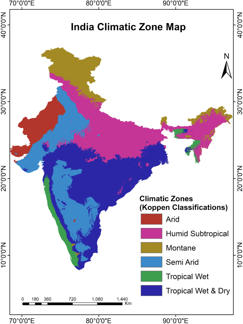
Koeppen-Geiger Climate Classification of India. Source: Wikimedia Commons
The Rhythm of Seasons
The Cold Weather Season (Winter): Mid-November to February. Characterized by Western Disturbances, which are cyclonic storms originating from the Mediterranean Sea, causing light rain in the north, beneficial for Rabi crops.
The Hot Weather Season (Summer): March to May. Hot, dry winds called 'Loo' blow in the northern plains. Pre-monsoon showers like 'Mango Showers' (Kerala & Karnataka), 'Blossom Shower' (for coffee in Karnataka) and 'Kalbaisakhi' or Nor'westers (Bengal & Assam) occur.
Advancing Monsoon (Rainy Season): June to September. The 'burst' of the monsoon provides over 75% of India's annual rainfall. It arrives in two branches: the Arabian Sea branch and the Bay of Bengal branch.
Retreating Monsoon (Transition Season): October-November. Withdrawal of monsoon leads to clear skies and a rise in temperature and humidity, a condition known as 'October heat'. This season is the main rainy period for the Tamil Nadu coast due to northeast trade winds picking up moisture from the Bay of Bengal.
Additional Exam-Oriented Points:
The Arabian Sea branch of the monsoon is stronger than the Bay of Bengal branch.
Mawsynram in the Khasi Hills of Meghalaya receives the highest rainfall in the world.
The rain-shadow area of the Western Ghats (e.g., parts of Maharashtra, Karnataka) receives very little rainfall.
El Niño is generally associated with a weak monsoon in India, while La Niña is associated with a strong monsoon.
A positive Indian Ocean Dipole (IOD) is favorable for the Indian monsoon.
'Monsoon trough' is a low-pressure area over the northern plains that attracts the monsoon winds.
'Break' in the monsoon refers to a period of dry spell during the rainy season.
Koeppen's Classification for India: Amw (Monsoon with short dry season - Malabar Coast), As (Monsoon with dry summer - Coromandel Coast), Aw (Tropical Savanna - Peninsular Plateau), BShw (Semi-arid steppe - Rajasthan), Cwg (Monsoon with dry winter - Ganga plain), E (Polar type - Himalayas).
11. Natural Vegetation
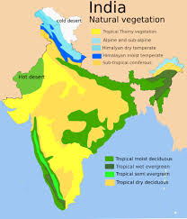
India's diverse climate and relief support a rich variety of natural vegetation, from lush rainforests to thorny scrubs. Indian forests are broadly classified into five major types.
Natural Vegetation Map of India. Source: Wikimedia Commons
Tropical Evergreen Forests: Found in high rainfall areas (>200 cm) like the Western Ghats and the Northeast. They are multi-layered with dense canopy and no definite time to shed leaves. Key species: Rosewood, Mahogany, Ebony, Aini. Also called rainforests.
Tropical Deciduous Forests: The most widespread forests, also called Monsoon Forests. Found in regions with rainfall between 70-200 cm. They shed their leaves in the dry season. Key species: Teak, Sal, Sandalwood, Shisham, Neem. They are further divided into moist and dry deciduous based on rainfall.
Tropical Thorn Forests and Scrubs: Found in semi-arid areas with rainfall <70 cm. Vegetation consists of thorny trees and bushes with deep roots to seek moisture. Key species: Acacia, Palms, Cacti, Babul, Kikar.
Montane Forests: Vegetation varies with altitude in the Himalayas. Wet temperate forests (1000-2000m), Coniferous forests (pine, deodar, spruce, cedar) (1500-3000m), and Alpine vegetation (grasslands, mosses) (>3600m) are found successively. In Peninsular India, these are found in the Nilgiris and Anaimalai hills, known as Shola forests.
Mangrove Forests: Found in coastal deltas influenced by tides. They have stilt-like roots (pneumatophores) to breathe. The Sunderbans in the Ganga-Brahmaputra delta is home to the world's largest mangrove forests, named after the Sundari tree.
Additional Exam-Oriented Points:
'Shola' forests are patches of stunted tropical montane forest found in valleys amid rolling grasslands in the higher mountain regions of South India.
The India State of Forest Report (ISFR) is a biennial publication of the Forest Survey of India (FSI).
The National Forest Policy of 1988 recommends that 33% of the geographical area should be under forest cover.
Social Forestry refers to the management and protection of forests and afforestation on barren lands with the purpose of helping in the environmental, social and rural development.
Sandalwood is primarily found in the dry deciduous forests of Karnataka.
Royal Bengal Tiger is the famous animal of the Sunderbans.
Himalayan vegetation ranges from tropical to tundra type with increasing altitude.
Mangroves act as a natural barrier against coastal erosion and tsunamis.
12. Soils of India
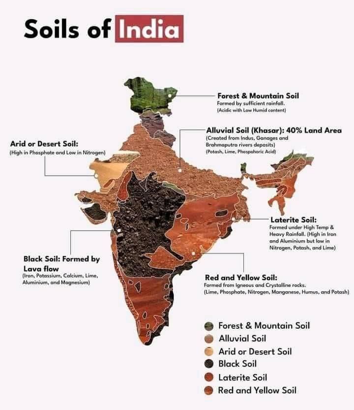
Soil is a vital natural resource, and India possesses a variety of soil types due to its diverse parent rock material, climate, and relief. The Indian Council of Agricultural Research (ICAR) has classified Indian soils.
Major Soil Types of India. Source: Wikimedia Commons
Major Soil Types
Alluvial Soils: Most widespread and fertile, covering the entire Northern Plains. They are rich in potash but poor in phosphorus and nitrogen. Divided into older alluvium (Bhangar) and newer alluvium (Khadar). Ideal for growing cereals like wheat and rice.
Black Soils (Regur Soils): Found in the Deccan Trap region. Ideal for cotton, hence also called 'black cotton soil'. They are clayey, highly retentive of moisture, and swell when wet. Rich in lime, iron, and magnesia but deficient in phosphorus.
Red and Yellow Soils: Develop on crystalline igneous rocks in low rainfall areas of the eastern and southern Deccan. The reddish colour is due to high iron content in diffused form; it looks yellow in a hydrated form. Generally poor in nutrients.
Laterite Soils: Form in areas with high temperature and heavy rainfall due to intense leaching. Rich in iron and aluminum but poor in nutrients and humus. Suitable for cashews, tea, and coffee with adequate manuring.
Arid Soils: Found in western Rajasthan. Sandy, saline, and lack humus and moisture. High salt content makes them unfit for cultivation, but can be made productive with proper irrigation.
Forest Soils: Found in mountainous areas. They are loamy and silty in valley sides and acidic with low humus content in snow-bound upper slopes.
Saline and Alkaline Soils: Also known as Usar soils. Found in arid and semi-arid regions. They have a high concentration of salts due to poor drainage and high evaporation. Can be reclaimed by adding gypsum.
Additional Exam-Oriented Points:
Soil degradation is a major problem. Sheet erosion, gully erosion, and soil salinity are major threats.
The process of soil formation is called pedogenesis.
'Karewa' soils of Kashmir are lacustrine deposits rich in humus, ideal for saffron cultivation.
Black soils are self-ploughing as they develop deep cracks during the dry season.
Laterite soil is used to make bricks for construction.
Peaty soils are found in areas of heavy rainfall and high humidity, rich in organic matter but acidic in nature.
The Central Soil Salinity Research Institute is located in Karnal, Haryana.
Soil health can be improved through measures like crop rotation, contour ploughing, terrace farming, and afforestation.